Romsdal, Norway
Romsdalseggen Ridge Walk - Norway's Best Valley Panorama
Romsdalseggen hike: 10 km ridge above Romsdal valley, 970 m climb. The best hiking trail from the Trollstigen area and Norway's most-photographed valley panorama. Access, difficulty, and logistics guide.
Published May 8, 2026 · Last updated May 8, 2026 · researched
Map data: © OpenStreetMap contributors, tiles by OpenTopoMap (CC-BY-SA). Approximate location — verify the exact route on the official trail page before hiking.
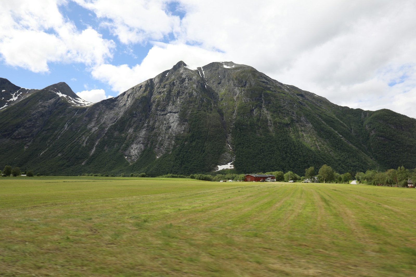
Romsdalseggen is a 10 km ridge traverse above the Romsdal valley, with views down to the Trollstigen road and across to Romsdalshornet - the cliff that defines the region. It’s a point-to-point with bus transport between the trailheads, finishes on a cable-stair descent, and gives you the sweeping ridge-walk experience without Trolltunga’s 28 km punishment.
Locals call it the better day. They’re probably right.
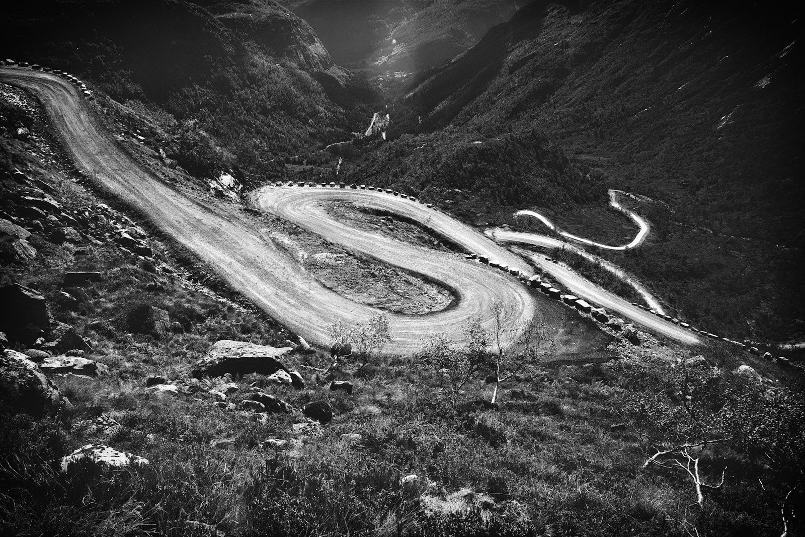
Photo: Fjell Photography on Unsplash.
The route
The classic direction is Vengedalen → Åndalsnes, point-to-point. Take the morning bus from Åndalsnes to Vengedalen (around 30 minutes), walk back over the ridge.
| Stage | Distance | Notes |
|---|---|---|
| Start at Vengedalen (700 m) | - | Marked P, parking + shuttle bus |
| Climb to ridge | 3 km | Steep, 700 m gain over the first 3 km |
| Ridge traverse | 4 km | The famous section - exposed in places, with chains in two |
| Descent via Mjølva | 3 km | Stone steps + cable section near the end |
| Finish at Åndalsnes (10 m) | - | Train station, restaurants, ferry |
Total: 10 km point-to-point, 970 m elevation gain.
When it’s open
The official “open” season is late June to mid-September. Outside that window the ridge can hold snow late and the chain-section gets icy.
The Vengedalen access road opens with the trail and closes when snow shuts it. Check the Visit Åndalsnes trail status before driving.
What the ridge is actually like
- The first 3 km is the hardest physically. Steep grass, then loose rock, then a near-vertical scramble onto the ridge proper. Trekking poles are essential.
- The ridge traverse (4 km) is undulating with two genuinely exposed sections. Chains are bolted in for the steepest scrambles. If you’re confident on Trolltunga’s final approach, you’re fine here.
- The cable-stair descent at the end is dramatic but safe - wide steps, secure handrails, well-maintained. It drops you almost into Åndalsnes town centre.
How it compares to Trolltunga
| Trolltunga | Romsdalseggen | |
|---|---|---|
| Distance | 28 km out-and-back | 10 km point-to-point |
| Elevation gain | 800 m | 970 m |
| Time | 10-12 h | 6-8 h |
| Photo moment | Standing on the cliff | Looking down the entire ridge |
| Crowds (July) | 1500/day | 200-400/day |
| Difficulty | Endurance + altitude | Technical scrambling on ridge |
| Transport | Shuttle from P2 | Bus from Åndalsnes |
| Better for | First-time hikers wanting THE photo | Confident walkers wanting a real ridge day |
If you’ve already done Trolltunga and want a different kind of day in the same region, Romsdalseggen is the answer.
Why the locals walk this one
A few reasons:
- Variety in 10 km. You climb a grass slope, traverse a sharp ridge, scramble two short rock sections, descend a cable stair into a fjord-side town. Trolltunga is mostly the same gradient for 14 km each way.
- You finish in a town, not a parking lot. Åndalsnes has restaurants, a station, a fjord. There is nothing at the Trolltunga trailhead but a bus stop and exhausted hikers.
- The view from Romsdalseggen down into the valley - with the Trollstigen road switchbacks visible - is more memorable than the view from Trolltunga, which is essentially “fjord, big”. Different vibe.
The only reason most international visitors don’t do Romsdalseggen is that they haven’t heard of it.
What to bring
- Hard-shell ankle boots with sticky rubber soles - there are wet-rock sections on the chain ridge
- Trekking poles - essential for the descent
- Helmet (light) - local recommendation for the chain sections, especially in groups (rockfall from above)
- Map - the marked path is reliable but the maps app does not always work on the ridge
- Lunch - there’s no infrastructure between the two ends
- Bus ticket for Vengedalen, booked in advance during peak July
Practical
- Bus from Åndalsnes to Vengedalen: Roughly 30 minutes, runs hourly mid-June to mid-September, fewer in shoulder season. Book at the tourist office or via Trolltinden Aktiv.
- Parking at Vengedalen: A small lot, easily fills on July weekends. Shuttle is the recommended option.
- Train from Oslo: The Rauma Railway from Dombås to Åndalsnes is one of Norway’s most scenic, ends at the trailhead.
Common questions
Is it worth it if I’m already doing Trolltunga?
Yes - they are different days. Romsdalseggen gives you the ridge-walk experience; Trolltunga gives you the cliff-edge photograph. Both, if you have time.
How dangerous is the ridge?
Two specific sections require chains. Both are short (5-10 m) and the chains are well-maintained. The ridge between them has a path wide enough for normal walking. Vertigo-prone hikers should still think carefully - the views in both directions are precipitous.
Can I do the ridge in the opposite direction?
Yes - Åndalsnes → Vengedalen. The first kilometre is then the cable-stair climb, which is harder going up than down. Most people prefer the standard direction.
Is it doable in shoulder season?
Late June and early September are excellent. Mid-September is variable - check trail conditions. Outside that, expect snow on the chain section.
Keep reading
- Trolltunga - the longer, more famous alternative
- The best time to hike in Norway - when Romsdalseggen is open
- Lofoten vs the fjords - picking your Norway region
- Hiking in Norway: the complete guide - the hub