
Lysefjord, Norway
Kjeragbolten - Hiking Kjerag Above the Lysefjord
Hike to Kjeragbolten: the boulder wedged 1000 m above the Lysefjord, Norway. 11 km return, 570 m climb, and one of the most dramatic views in Norway.
Published May 5, 2026 · Last updated May 5, 2026 · researched
Map data: © OpenStreetMap contributors, tiles by OpenTopoMap (CC-BY-SA). Approximate location — verify the exact route on the official trail page before hiking.
Kjerag is the cliff on the south side of the Lysefjord - a flat-topped 1000-metre wall with a 5-cubic-metre boulder, the Kjeragbolten, wedged in a crack 984 metres above the water. The hike is 11 km return with three serious climbs, and the summit photograph is the one people Instagram. The reality is harder than the photo suggests.
Compared to Preikestolen - its cousin on the north side of the same fjord - Kjerag is longer, steeper, less crowded, and only open for a shorter season. Most visitors who do both say Kjerag is the better walk; Preikestolen is the better postcard.
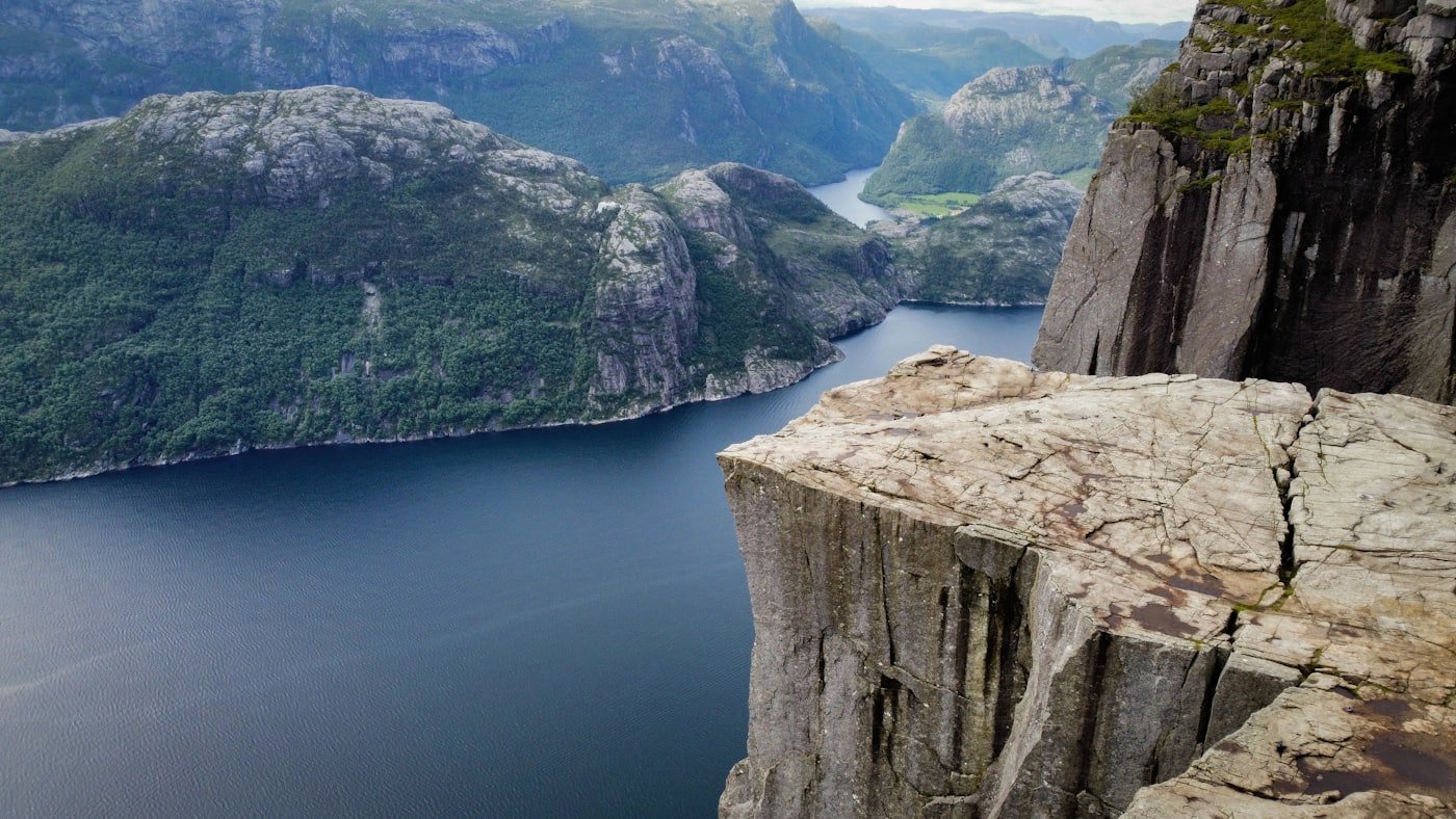
Photo: Mario von Rotz on Unsplash.
The route
The trail starts at Øygardstøl at the end of the road from Lysebotn. From there:
- Climb 1: A nearly vertical scramble up bolted chains for the first 200 m. The hardest section of the day, in the first 30 minutes.
- Plateau 1: Rolling moorland to the next valley.
- Climb 2: Less steep but longer.
- Plateau 2: Open mountain country.
- Climb 3: Final push to the Kjerag summit plateau.
- The boulder: ~5 km in, signposted off the main trail. Stepping onto it is optional.
Total: 5.5 km each way, three substantial climbs separated by flat moor walking.
When it’s open
The road to Øygardstøl is closed in winter (typically October to late May). When the road is open, the trail is open. Specific dates depend on snowmelt - check with Lysefjorden Tourist Office before driving.
| Period | Status |
|---|---|
| June to September | Trail and road open |
| May / October | Variable - call before driving |
| November to April | Road closed; trail under deep snow |
The Lysebotn road from the inland side is famous in itself - 27 hairpin bends and a 20% gradient. The view from Øygardstøl into the Lysefjord at the top of the road is the second photo of the day, after the boulder.
Stepping onto the Kjeragbolten
The boulder is 5 cubic metres of solid rock wedged in a crack. It has held people since the Ice Age and there has never been a recorded fall - but if you slip while stepping across, the drop is 984 metres.
Before stepping on:
- Check the rock is dry (do not attempt in rain or fog)
- Watch how others step across - there is one short jump
- If you are uncertain, take the photo from the side ledge instead. It looks identical online.
What to bring
- Hard ankle boots - the granite is wet half the time and there are loose rocks on the climbs
- Trekking poles - useful for both ascents and descents
- A printed map - phone signal is patchy in the valleys
- 2 litres of water - the highest stream is around km 4 and runs dry in late summer
- A dry layer in your pack for the summit (it’s exposed and windy)
How it compares to Preikestolen
| Preikestolen | Kjerag | |
|---|---|---|
| Distance | 8 km | 11 km |
| Elevation | 334 m | 570 m |
| Difficulty | Moderate | Hard |
| Season | Mid-May to October | June to September |
| Crowd peak | 1000+ per day | 300-500 per day |
| Cost (parking + transport) | ~150 NOK | ~250 NOK + petrol to Lysebotn |
| Photo moment | Standing on flat slab | Stepping onto boulder |
| Better for | First-time fjord walkers | Confident hikers wanting a quieter trail |
Common questions
Is it harder than Preikestolen?
Yes - significantly. Longer distance, steeper climbs, more exposed plateau walking. Time it 6-7 hours instead of Preikestolen’s 4.
Can I do both in the same day?
In theory yes (they are 90 minutes apart by car + ferry). In practice no - by the time you finish Kjerag, the last ferry back from Forsand has left.
Is there a way to see Kjerag without the climb?
The Lysefjord cruise from Stavanger passes directly under the cliff. You see the wall; you don’t see the boulder.
How dangerous is the boulder?
People have BASE-jumped from Kjerag for decades - the cliff is famous for it. The Kjeragbolten itself is extremely safe to step on in dry conditions. The problem is rain or snow film on the rock, which can make the step slick and the consequences absolute.
Sources: Visit Norway, Lysefjorden Tourist Office, and the Stavanger Trekking Association (STF).
Keep reading
- Preikestolen - the cliff on the other side of the same fjord
- The best time to hike in Norway - when the Lysebotn road is open
- Allemannsretten - wild-camping rules in Lysefjord country
- Hiking in Norway: the complete guide - the hub